ROYLCO INC. Dry Erase USA Map Class Pack R-59091
$14.99
Out of stock
Brand:
Roylco®
Description
Ages 6
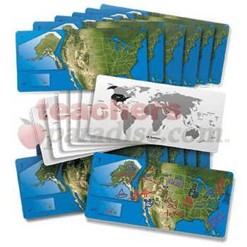
Gain a sense of the beauty of American geography! The United States is represented by a satellite view of the country with insets of Alaska and Hawaii to scale. We’ve drawn in each state. Use the maps to identify the States and their capitals. Draw landmarks and geographical formations! On the reverse side, take a look at the entire world and the position of the United States and it’s territories on the globe. Maps are 5 x 11″ (13 x 28 cm). Includes teacher guide. 24 American dry erase maps. by ROYLCO INC.
Related Products

he Don't know beans about...Animals game includes 60 questions cards and 60 answer cards. As each correct answer is given, ...
Ball point Gel in a variety of pack options. Quality felt tip. Non toxic and safe. Vented caps. Conforms to ...

SPECIAL DESIGN HANDLES FOR YOUNGER CHILDREN TO BE ABLE TO FIT RIGHT INTO THE PALMS OF THEIR HANDS. THESE STAMPS ...

Use these colorful, reversible shapes for patterning activities and bulletin board borders and to add interest to art projects. Approx ...
17in. x 22in. Resource guide on back ...
When a little girl and her dog go walking, they finds lots of things to count from ladybugs in a ...
HI DENSITY FOAM BALLS...High density, training balls...Ideal for various ball games indoors and outdoors...For all age groups ...